CMLS98B Example
Purpose | Processes
and Assumptions | Installation |
Use | Example |
References | Acknowledgements
Program Structure |
Platform Dependencies | File
Structures
ILLUSTRATION OF PROGRAM USE
Suppose we have a management unit which contains soils classified as Cobb
loamy sand, Eufaula sand, Noble sandy loam, and Pond Creek sandy loam. We
have soil properties for each soil at three locations. We are interested
in predicting the depth of Basagran (bentazon sodium salt) 120 days after
application and the amount of bentazon leached below the 1 m and 1.5 m depths
(whenever the chemical passes those depths). The field is irrigated with
5 cm of water every 14 days from June 10 to September 1. Peanuts are planted
from May 1 to May 15. The herbicide is applied on the soil surface 15 - 30
days after planting. The management unit is located in Caddo County, Oklahoma,
near the Ft. Cobb weather station. Since we do not know the weather which
we will encounter this year, we will use Monte Carlo techniques to obtain
results for 500 weather sequences generated by WGEN for weather parameters
extracted from many years of historical weather data at Ft. Cobb. Results
for the 500 sequences will then be summarized (outside of CMLS98B) to answer
the questions of interest.
Input File: Table 2 shows the input file required to carry out this
simulation. This file describes the simulations specified above. There are
several additional points to be made.
- Comments and blank lines are not needed in the file. They are just for adding information and for improving readability of the text.
- Crop coefficients as a function of time after planting are obtained from a file called "cropfile". The contents of this file are described and shown in the Appendix.
- Parameters needed by WGEN for generating weather for the Ft. Cobb station are stored in a file called ok3281.par. This file is listed in the Appendix.
- The file specifies that simulation begins on day 1 of year 1 and ends on day 365 of year 10. Computations actually end when all of the desired output values have been computed. Often this is less than the maximum time specified. If historical weather had been specified, the calendar year would have been entered rather than year 1 or year 10.
- Note that the general block does not contain the keyword Seed. As a result, the random number generator obtained its seed from the system clock.
- Note that the Mode keyword is not in the general block. This means that the one set of weather is used for all 12 soil systems. Another weather sequence is then generated and used for all 12 soil systems for the second round. This process continues until 500 weather sequences are generated and used.
- The specified scenario did not include the rooting depth of the peanuts. This was taken to be 0.6 m in this case. The value is specified in the CurveNoRootDepth line as 0.6. Units are meters since the length units specified in LengthUnits is M.
- Note that the amount of bentazon applied was specified in the Chemical line as 1.0. This means the amounts computed can be interpreted as the fraction of the original amount still remaining in the profile.
- Since the ChemicalProperty keyword is missing in this file, the partition coefficient, Kd is calculated using equation 3 and the Koc and organic carbon values.
- In this example, all soil layers have the same thickness. This is not required.
Table 2. Sample input file for illustrating program.
Comment Basagran leaching in irrigated peanuts in Caddo County,
OK
Comment ****** Beginning of System Block ********
CheckFile Basagran.chk
OutputFile Basagran.out
Output Traveltime 1.0 1.5
Output Depth 120
Output Amount
Output InfiltrationET
Crop peanuts cropfile
ET Generated ok3281.par SCSBlaneyCriddle 1.0
Infiltration Generated ok3281.par
Irrigation Periodic 161 244 14 50.0
BeginSimulation 1 1
EndSimulation 10 365
PlantingDate 121 135
NumberofSimulations 500
LengthUnits M mm
Comment ********* End of General Block **********
Comment ****** Beginning of System Block ********
SystemIndex 1
SoilName Eufaula_1
CurveNoRootDepth 0.0 0.6
Chemical Relative 1 15 30 0.0 1.0 34 20 bentazon
SoilProperty 1 0.20 0.165 1.580 12.5 1.3 40.4
SoilProperty 2 0.40 0.045 1.540 9.6 1.3 41.9
SoilProperty 3 0.60 0.067 1.580 7.1 1.1 40.4
SoilProperty 4 0.80 0.079 1.380 10.6 1.1 47.9
SoilProperty 5 1.00 0.067 1.510 5.7 1.2 43.0
SoilProperty 6 1.20 0.079 1.590 9.4 1.5 40.0
SoilProperty 7 1.40 0.061 1.540 6.7 1.7 41.9
SoilProperty 8 1.60 0.100 1.580 9.4 2.3 40.4
SystemIndex 2
SoilName Eufaula_2
CurveNoRootDepth 0.0 0.6
Chemical Relative 1 15 30 0.0 1.0 34 20 bentazon
SoilProperty 1 0.20 0.388 1.480 14.1 1.9 44.2
SoilProperty 2 0.40 0.107 1.550 7.4 0.9 41.5
SoilProperty 3 0.60 0.083 1.510 11.3 1.4 43.0
SoilProperty 4 0.80 0.076 1.460 11.9 1.3 44.9
SoilProperty 5 1.00 0.055 1.490 6.5 1.6 43.8
SoilProperty 6 1.20 0.072 1.510 6.2 1.6 43.0
SoilProperty 7 1.40 0.057 1.530 6.0 3.5 42.3
SoilProperty 8 1.60 0.060 1.540 5.4 1.2 41.9
SystemIndex 3
SoilName Eufaula_3
CurveNoRootDepth 0.0 0.6
Chemical Relative 1 15 30 0.0 1.0 34 20 bentazon
SoilProperty 1 0.20 0.214 1.510 9.4 1.7 43.0
SoilProperty 2 0.40 0.089 1.490 6.4 1.4 43.8
SoilProperty 3 0.60 0.067 1.520 5.3 1.2 42.6
SoilProperty 4 0.80 0.081 1.600 5.6 1.1 39.6
SoilProperty 5 1.00 0.075 1.540 5.2 1.4 41.9
SoilProperty 6 1.20 0.071 1.550 8.5 1.4 41.5
SoilProperty 7 1.40 0.074 1.600 8.0 1.6 39.6
SoilProperty 8 1.60 0.075 1.590 6.7 2.3 40.0
SystemIndex 4
SoilName Cobb_1
CurveNoRootDepth 0.0 0.6
Chemical Relative 1 15 30 0.0 1.0 34 20 bentazon
SoilProperty 1 0.20 0.315 1.570 23.5 5.8 40.8
SoilProperty 2 0.40 0.316 1.540 31.6 12.2 41.9
SoilProperty 3 0.60 0.266 1.550 30.2 12.9 41.5
SoilProperty 4 0.80 0.266 1.550 30.2 12.9 41.5
SoilProperty 5 1.00 0.172 1.550 30.2 12.9 41.5
SoilProperty 6 1.20 0.166 1.520 24.5 7.0 42.6
SoilProperty 7 1.40 0.096 1.460 24.2 5.7 44.9
SoilProperty 8 1.60 0.101 1.510 25.6 10.1 43.0
SystemIndex 5
SoilName Cobb_2
CurveNoRootDepth 0.0 0.6
Chemical Relative 1 15 30 0.0 1.0 34 20 bentazon
SoilProperty 1 0.20 0.309 1.620 17.5 5.3 38.9
SoilProperty 2 0.40 0.355 1.540 30.6 9.7 41.9
SoilProperty 3 0.60 0.304 1.610 30.4 13.2 39.2
SoilProperty 4 0.80 0.289 1.640 30.1 13.7 38.1
SoilProperty 5 1.00 0.204 1.610 29.3 9.4 39.2
SoilProperty 6 1.20 0.126 1.440 25.9 6.2 45.7
SoilProperty 7 1.40 0.115 1.460 25.5 5.9 44.9
SoilProperty 8 1.60 0.058 1.450 24.0 4.6 45.3
SystemIndex 6
SoilName Cobb_3
CurveNoRootDepth 0.0 0.6
Chemical Relative 1 15 30 0.0 1.0 34 20 bentazon
SoilProperty 1 0.20 0.263 1.630 21.4 6.1 38.5
SoilProperty 2 0.40 0.203 1.600 24.5 4.6 39.6
SoilProperty 3 0.60 0.101 1.420 19.5 2.0 46.4
SoilProperty 4 0.80 0.101 1.400 21.0 2.1 47.2
SoilProperty 5 1.00 0.096 1.430 19.9 4.0 46.0
SoilProperty 6 1.20 0.093 1.550 21.5 8.2 41.5
SoilProperty 7 1.40 0.067 1.560 23.4 8.5 41.1
SoilProperty 8 1.60 0.078 1.490 23.8 8.3 43.8
SystemIndex 7
SoilName Noble_1
CurveNoRootDepth 0.0 0.6
Chemical Relative 1 15 30 0.0 1.0 34 20 bentazon
SoilProperty 1 0.20 1.117 1.450 29.7 4.8 45.3
SoilProperty 2 0.40 0.311 1.420 23.3 4.7 46.4
SoilProperty 3 0.60 0.271 1.310 19.6 5.5 50.6
SoilProperty 4 0.80 0.240 1.440 20.5 7.0 45.7
SoilProperty 5 1.00 0.193 1.500 20.8 7.7 43.4
SoilProperty 6 1.20 0.212 1.520 21.5 7.5 42.6
SoilProperty 7 1.40 0.142 1.550 22.1 7.0 41.5
SoilProperty 8 1.60 0.133 1.520 20.7 6.6 42.6
SystemIndex 8
SoilName Noble_2
CurveNoRootDepth 0.0 0.6
Chemical Relative 1 15 30 0.0 1.0 34 20 bentazon
SoilProperty 1 0.20 0.497 1.490 27.7 4.6 43.8
SoilProperty 2 0.40 0.404 1.450 23.6 5.1 45.3
SoilProperty 3 0.60 0.329 1.410 21.1 5.6 46.8
SoilProperty 4 0.80 0.300 1.500 24.6 6.6 43.4
SoilProperty 5 1.00 0.157 1.480 21.3 7.1 44.2
SoilProperty 6 1.20 0.186 1.610 21.1 7.4 39.2
SoilProperty 7 1.40 0.128 1.610 19.6 6.8 39.2
SoilProperty 8 1.60 0.095 1.660 27.2 7.4 37.4
SystemIndex 9
SoilName Noble_3
CurveNoRootDepth 0.0 0.6
Chemical Relative 1 15 30 0.0 1.0 34 20 bentazon
SoilProperty 1 0.20 0.919 1.510 24.4 5.0 43.0
SoilProperty 2 0.40 0.376 1.600 18.3 5.5 39.6
SoilProperty 3 0.60 0.233 1.450 19.5 5.4 45.3
SoilProperty 4 0.80 0.224 1.580 16.2 7.5 40.4
SoilProperty 5 1.00 0.146 1.560 20.1 7.0 41.1
SoilProperty 6 1.20 0.167 1.610 19.0 7.4 39.2
SoilProperty 7 1.40 0.132 1.590 18.0 6.0 40.0
SoilProperty 8 1.60 0.123 1.560 18.4 5.5 41.1
SystemIndex 10
SoilName Pond Creek_1
CurveNoRootDepth 0.0 0.6
Chemical Relative 1 15 30 0.0 1.0 34 20 bentazon
SoilProperty 1 0.20 0.510 1.620 27.7 7.2 38.9
SoilProperty 2 0.40 0.727 1.410 33.6 10.8 46.8
SoilProperty 3 0.60 0.665 1.380 34.2 13.0 47.9
SoilProperty 4 0.80 0.566 1.470 32.6 13.5 44.5
SoilProperty 5 1.00 0.516 1.460 34.5 15.6 44.9
SoilProperty 6 1.20 0.357 1.520 33.6 13.6 42.6
SoilProperty 7 1.40 0.292 1.500 32.2 7.1 43.4
SoilProperty 8 1.60 0.292 1.470 32.6 8.8 44.5
SystemIndex 11
SoilName Pond Creek_2
CurveNoRootDepth 0.0 0.6
Chemical Relative 1 15 30 0.0 1.0 34 20 bentazon
SoilProperty 1 0.20 0.558 1.590 29.8 11.9 40.0
SoilProperty 2 0.40 0.582 1.530 36.2 16.7 42.3
SoilProperty 3 0.60 0.819 1.520 37.2 15.0 42.6
SoilProperty 4 0.80 0.665 1.430 35.2 8.3 46.0
SoilProperty 5 1.00 0.496 1.460 32.4 11.9 44.9
SoilProperty 6 1.20 0.304 1.530 34.7 11.3 42.3
SoilProperty 7 1.40 0.222 1.550 32.6 10.0 41.5
SoilProperty 8 1.60 0.135 1.540 32.2 9.5 41.9
SystemIndex 12
SoilName Pond Creek_3
CurveNoRootDepth 0.0 0.6
Chemical Relative 1 15 30 0.0 1.0 34 20 bentazon
SoilProperty 1 0.20 0.599 1.420 31.3 6.6 46.4
SoilProperty 2 0.40 0.584 1.370 35.6 9.5 48.3
SoilProperty 3 0.60 0.675 1.390 34.7 12.3 47.5
SoilProperty 4 0.80 0.580 1.400 36.4 11.9 47.2
SoilProperty 5 1.00 0.445 1.490 34.1 13.6 43.8
SoilProperty 6 1.20 0.294 1.530 33.2 11.1 42.3
SoilProperty 7 1.40 0.173 1.540 33.7 9.7 41.9
SoilProperty 8 1.60 0.132 1.530 30.6 8.2 42.3
Output File: Table 3 is a partial listing of the output file Basagran.out produced after executing CMLS98B basagran.in. This output is without any headers since WithHeader did not follow the output file name. The output file contains the following data:
- Column 1 is the simulation number for this row of data. This can also be interpreted as a weather sequence index.
- Column 2 is the SystemIndex identifier.
- Columns 3-5, 6-8, and 9-11 represent time, depth, amount triplets for the outputs specified. Column 4 has a value of 1 in all rows. Therefore, column 3 represents the time required for the chemical pulse to reach 1 m. Column 5 represents the amount of chemical in the pulse passing 1 m. Columns 6 and 8 represent these values for the depth of 1.5 m (shown in column 7). Column 9 has a value of 120 for all rows. Columns 10 and 11 show the computed chemical depths and amounts 120 days after the chemical was applied. The amounts are the same for all soils and all weather sequences since the half-life was the same for all soils and it was not a function of soil depth. If more than 3 output depths and times had been requested, the number of triplets in each row would have been greater.NOTE: If the chemical does not reach the depth specified during the simulation, the travel time output will be -1 and the amount will be zero.
- Columns 12 - 17 represent total evapotranspiration, potential evapotranspiration, rainfall, infiltration, irrigation, and runoff during the period simulated, respectively. These are always the last 6 columns in the output table. Runoff amounts shown in this example are all zero since all curve numbers were zero in the input file.
Table 3. First 48 of 6000 records of basagran.out output file.
| 1 | 1 | 133 | 1 | 9.96E-03 | 133 | 1.5 | 9.96E-03 | 120 | 0.88 | 1.51E-02 | 622.09 | 834.68 | 681.74 | 981.74 | 300 | 0 |
| 1 | 2 | 125 | 1 | 1.31E-02 | 125 | 1.5 | 1.31E-02 | 120 | 0.69 | 1.51E-02 | 643.59 | 834.68 | 681.74 | 981.74 | 300 | 0 |
| 1 | 3 | 60 | 1 | 1.25E-01 | 88 | 1.5 | 4.74E-02 | 120 | 1.63 | 1.56E-02 | 485.81 | 805.38 | 529.08 | 829.08 | 300 | 0 |
| 1 | 4 | 326 | 1 | 1.24E-05 | 383 | 1.5 | 1.72E-06 | 120 | 0.34 | 1.51E-02 | 950.97 | 1068.76 | 1230.38 | 1580.38 | 350 | 0 |
| 1 | 5 | 330 | 1 | 1.08E-05 | 387 | 1.5 | 1.50E-06 | 120 | 0.39 | 1.51E-02 | 942.77 | 1068.76 | 1230.38 | 1580.38 | 350 | 0 |
| 1 | 6 | 143 | 1 | 7.04E-03 | 322 | 1.5 | 1.42E-05 | 120 | 0.39 | 1.51E-02 | 837.85 | 959.04 | 1022.1 | 1322.1 | 300 | 0 |
| 1 | 7 | 186 | 1 | 1.59E-03 | 356 | 1.5 | 4.38E-06 | 120 | 0.69 | 1.51E-02 | 900.74 | 1012.13 | 1190.5 | 1490.5 | 300 | 0 |
| 1 | 8 | 211 | 1 | 6.67E-04 | 370 | 1.5 | 2.70E-06 | 120 | 0.31 | 1.51E-02 | 899.74 | 1012.13 | 1190.5 | 1490.5 | 300 | 0 |
| 1 | 9 | 153 | 1 | 4.98E-03 | 355 | 1.5 | 4.54E-06 | 120 | 0.33 | 1.51E-02 | 859.30 | 993.29 | 1098.04 | 1398.04 | 300 | 0 |
| 1 | 10 | 380 | 1 | 1.91E-06 | 1287 | 1.5 | 4.25E-20 | 120 | 0.4 | 1.51E-02 | 3272.02 | 3609.27 | 2955.04 | 4155.03 | 1200 | 0 |
| 1 | 11 | 391 | 1 | 1.30E-06 | 1298 | 1.5 | 2.90E-20 | 120 | 0.31 | 1.51E-02 | 3241.61 | 3609.27 | 2955.04 | 4155.03 | 1200 | 0 |
| 1 | 12 | 393 | 1 | 1.22E-06 | 1300 | 1.5 | 2.71E-20 | 120 | 0.29 | 1.51E-02 | 3318.24 | 3609.27 | 2955.04 | 4155.03 | 1200 | 0 |
| 2 | 1 | 142 | 1 | 7.29E-03 | 178 | 1.5 | 2.09E-03 | 120 | 0.85 | 1.51E-02 | 690.75 | 877.39 | 668.53 | 968.53 | 300 | 0 |
| 2 | 2 | 136 | 1 | 8.97E-03 | 172 | 1.5 | 2.58E-03 | 120 | 0.72 | 1.51E-02 | 718.11 | 877.39 | 668.53 | 968.53 | 300 | 0 |
| 2 | 3 | 38 | 1 | 2.68E-01 | 68 | 1.5 | 9.47E-02 | 120 | 1.98 | 1.56E-02 | 521.49 | 827.93 | 529.08 | 829.08 | 300 | 0 |
| 2 | 4 | 392 | 1 | 1.26E-06 | 1070 | 1.5 | 7.85E-17 | 120 | 0.38 | 1.51E-02 | 2453.02 | 2821.24 | 2070.1 | 2970.1 | 900 | 0 |
| 2 | 5 | 394 | 1 | 1.17E-06 | 692 | 1.5 | 3.84E-11 | 120 | 0.4 | 1.51E-02 | 1703.22 | 1881.75 | 1607.57 | 2207.57 | 600 | 0 |
| 2 | 6 | 317 | 1 | 1.69E-05 | 397 | 1.5 | 1.06E-06 | 120 | 0.43 | 1.51E-02 | 1107.54 | 1184.67 | 1082.55 | 1482.55 | 400 | 0 |
| 2 | 7 | 340 | 1 | 7.63E-06 | 689 | 1.5 | 4.26E-11 | 120 | 0.29 | 1.51E-02 | 1732.42 | 1881.75 | 1607.57 | 2207.57 | 600 | 0 |
| 2 | 8 | 342 | 1 | 7.12E-06 | 691 | 1.5 | 3.98E-11 | 120 | 0.34 | 1.51E-02 | 1730.42 | 1881.75 | 1607.57 | 2207.57 | 600 | 0 |
| 2 | 9 | 351 | 1 | 5.21E-06 | 578 | 1.5 | 2.00E-09 | 120 | 0.35 | 1.51E-02 | 1610.40 | 1804.93 | 1447.55 | 2047.55 | 600 | 0 |
| 2 | 10 | 1096 | 1 | 3.19E-17 | 1119 | 1.5 | 1.44E-17 | 120 | 0.33 | 1.51E-02 | 2700.87 | 3008.49 | 2428.24 | 3428.24 | 1000 | 0 |
| 2 | 11 | 1099 | 1 | 2.87E-17 | 1122 | 1.5 | 1.29E-17 | 120 | 0.33 | 1.51E-02 | 2671.47 | 3008.49 | 2428.24 | 3428.24 | 1000 | 0 |
| 2 | 12 | 1108 | 1 | 2.10E-17 | 1122 | 1.5 | 1.29E-17 | 120 | 0.34 | 1.51E-02 | 2759.76 | 3015.18 | 2450.85 | 3450.85 | 1000 | 0 |
| 3 | 1 | 32 | 1 | 3.30E-01 | 188 | 1.5 | 1.48E-03 | 120 | 1.43 | 1.51E-02 | 724.92 | 893.05 | 690.88 | 990.88 | 300 | 0 |
| 3 | 2 | 78 | 1 | 6.70E-02 | 190 | 1.5 | 1.38E-03 | 120 | 1.29 | 1.51E-02 | 749.72 | 893.05 | 690.88 | 990.88 | 300 | 0 |
| 3 | 3 | 44 | 1 | 2.18E-01 | 64 | 1.5 | 1.09E-01 | 120 | 2.13 | 1.56E-02 | 534.62 | 795.65 | 536.7 | 836.7 | 300 | 0 |
| 3 | 4 | 737 | 1 | 8.07E-12 | 1071 | 1.5 | 7.58E-17 | 120 | 0.49 | 1.51E-02 | 2399.34 | 2786.33 | 2018.54 | 2918.54 | 900 | 0 |
| 3 | 5 | 716 | 1 | 1.67E-11 | 1069 | 1.5 | 8.13E-17 | 120 | 0.52 | 1.51E-02 | 2373.27 | 2784.86 | 2007.36 | 2907.36 | 900 | 0 |
| 3 | 6 | 392 | 1 | 1.26E-06 | 742 | 1.5 | 6.79E-12 | 120 | 0.62 | 1.51E-02 | 1718.21 | 1947.68 | 1530.1 | 2130.1 | 600 | 0 |
| 3 | 7 | 722 | 1 | 1.36E-11 | 1075 | 1.5 | 6.60E-17 | 120 | 0.41 | 1.51E-02 | 2417.07 | 2784.86 | 2007.36 | 2907.36 | 900 | 0 |
| 3 | 8 | 718 | 1 | 1.56E-11 | 1071 | 1.5 | 7.58E-17 | 120 | 0.46 | 1.51E-02 | 2414.07 | 2784.86 | 2007.36 | 2907.36 | 900 | 0 |
| 3 | 9 | 395 | 1 | 1.13E-06 | 740 | 1.5 | 7.28E-12 | 120 | 0.51 | 1.51E-02 | 1692.61 | 1947.68 | 1530.1 | 2130.1 | 600 | 0 |
| 3 | 10 | 1091 | 1 | 3.79E-17 | 1805 | 1.5 | 6.79E-28 | 120 | 0.41 | 1.51E-02 | 4181.49 | 4606.63 | 3439.41 | 4939.41 | 1500 | 0 |
| 3 | 11 | 1089 | 1 | 4.06E-17 | 1449 | 1.5 | 1.55E-22 | 120 | 0.41 | 1.51E-02 | 3248.57 | 3707.37 | 2789.68 | 3989.68 | 1200 | 0 |
| 3 | 12 | 1094 | 1 | 3.42E-17 | 1813 | 1.5 | 5.15E-28 | 120 | 0.41 | 1.51E-02 | 4266.81 | 4616.8 | 3507.99 | 5007.99 | 1500 | 0 |
| 4 | 1 | 113 | 1 | 1.99E-02 | 340 | 1.5 | 7.63E-06 | 120 | 1.43 | 1.51E-02 | 765.30 | 1013.93 | 643.89 | 943.89 | 300 | 0 |
| 4 | 2 | 115 | 1 | 1.86E-02 | 360 | 1.5 | 3.81E-06 | 120 | 1.12 | 1.51E-02 | 811.86 | 1048.58 | 741.17 | 1041.17 | 300 | 0 |
| 4 | 3 | 34 | 1 | 3.08E-01 | 76 | 1.5 | 7.18E-02 | 120 | 2.16 | 1.56E-02 | 473.63 | 823.66 | 396.24 | 696.24 | 300 | 0 |
| 4 | 4 | 1104 | 1 | 2.42E-17 | 1141 | 1.5 | 6.70E-18 | 120 | 0.33 | 1.51E-02 | 2642.72 | 3045.36 | 2099.82 | 3099.82 | 1000 | 0 |
| 4 | 5 | 1036 | 1 | 2.55E-16 | 1106 | 1.5 | 2.25E-17 | 120 | 0.48 | 1.51E-02 | 2477.23 | 2904.46 | 1995.68 | 2945.68 | 950 | 0 |
| 4 | 6 | 359 | 1 | 3.95E-06 | 1090 | 1.5 | 3.93E-17 | 120 | 0.54 | 1.51E-02 | 2438.11 | 2850.94 | 1927.86 | 2827.86 | 900 | 0 |
| 4 | 7 | 1040 | 1 | 2.22E-16 | 1109 | 1.5 | 2.03E-17 | 120 | 0.38 | 1.51E-02 | 2515.77 | 2899.2 | 1983.49 | 2933.49 | 950 | 0 |
| 4 | 8 | 1041 | 1 | 2.14E-16 | 1110 | 1.5 | 1.96E-17 | 120 | 0.42 | 1.51E-02 | 2512.77 | 2899.2 | 1983.49 | 2933.49 | 950 | 0 |
| 4 | 9 | 713 | 1 | 1.85E-11 | 1096 | 1.5 | 3.19E-17 | 120 | 0.47 | 1.51E-02 | 2399.71 | 2850.94 | 1927.86 | 2827.86 | 900 | 0 |
| 4 | 10 | 1433 | 1 | 2.70E-22 | 1777 | 1.5 | 1.79E-27 | 120 | 0.31 | 1.51E-02 | 4084.28 | 4572.43 | 3274.06 | 4774.06 | 1500 | 0 |
| 4 | 11 | 1134 | 1 | 8.54E-18 | 1466 | 1.5 | 8.60E-23 | 120 | 0.38 | 1.51E-02 | 3247.48 | 3759.18 | 2726.18 | 3926.18 | 1200 | 0 |
| 4 | 12 | 1446 | 1 | 1.72E-22 | 1783 | 1.5 | 1.46E-27 | 120 | 0.35 | 1.51E-02 | 4175.9 | 4582.11 | 3333.24 | 4833.24 | 1500 | 0 |
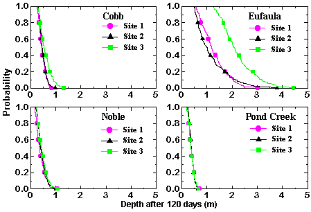
Results of Simulations: Figures 1 to 4 show summarized results for these simulations and some uses of CMLS98B. Data in the output file were processed externally to create these probability plots. Figure 1 shows the probability of the pesticide depth exceeding different values 120 days after application. Different lines within a graph represent different sites for that particular soil. Depths spanned within one line represent differences in depth due to different weather sequences used for this site. We can see that there is a low probability that the depth of chemical will exceed 1 meter during this time period for the Cobb, Noble, and Pond Creek soils. However, the probability of exceeding 1 m in the Eufaula soil ranges from approximately 60% to 100% for the 3 sites.
 |
|
| Figure 1. | Probability of exceeding different depths 120 days after application. |
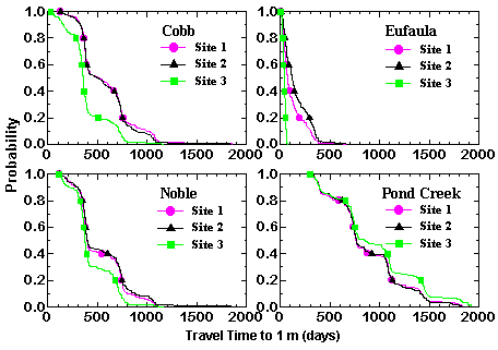
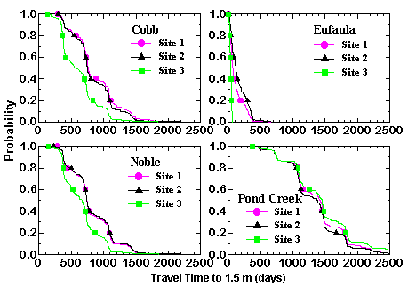
Figure 2 shows the probability of exceeding different times for the center of mass to reach a depth of 1 m. for each site and each soil (Recall that CMLS ignores dispersion so the chemical moves through the system as a sharp pulse at its center of mass). Figure 3 shows similar results for the 1.5 m depth. In figure 2, travel times range from only a few days to more than 1400 days for the Cobb soil. The ranges in travel time are similar for Noble and Pond Creek soils. Movement through the Eufaula soil is much more rapid with the maximum being approximately 500 days. The differences within a line are due to weather only. Different lines for each soil represent differences in predicted movement due to spatial variability of soil properties within that soil.
 |
|
| Figure 2. | Probability of exceeding different travel times to a depth of 1 m. |
 |
|
| Figure 3. | Probability of exceeding different travel times to a depth of 1.5 m. |
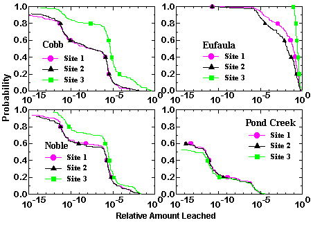
Figure 4 shows the probability of exceeding different amounts of pesticide leaching beyond the 1 m depth. Since the amount applied in each case had a value of 1, these amounts can be interpreted as the fraction of the amount applied leaching past a depth of 1 m. Differences due to weather and site can be observed. Clearly large differences in predicted values are common.
|
|
| Figure 4. | Probability of exceeding different amounts of pesticide leached beyond a depth of 1 m. |